Free NDA 2026 Preparation Guide
View Strategy

The Harappan World – NDA History Notes
Exam Relevance: High Frequency | Town Planning, Seals, Agriculture, Sites, Trade
Reading Time: 25–30 minutes | Last Updated: 2026
Many students believe Indian history begins with the Vedas. It does not. India had proper cities thousands of years before the Vedic period. This civilisation is called the Harappan Civilisation. It existed more than four thousand years ago. Its cities had planned roads, brick houses, and covered drains. This was not a simple village culture. This was a fully developed urban civilisation.
This civilisation was completely forgotten for nearly three thousand years. Nobody knew it had existed. Then, in the early twentieth century, archaeologists began digging at Harappa in present-day Pakistan. They found the buried remains of an ancient city. A second major site, Mohenjo-daro, followed shortly after. More excavations revealed that the civilisation covered parts of modern India, Pakistan, and Afghanistan, a total area bigger than ancient Egypt and Mesopotamia combined.
The Harappans had a writing system. Thousands of inscribed objects have been found. But that writing has never been deciphered. Everything we know about the Harappans comes from physical remains only: buildings, tools, seals, and pottery. This is why many conclusions about Harappan religion, government, and society remain uncertain.
NDA has asked questions from this chapter across many years. Town planning, the Great Bath, Harappan seals, farming evidence at Kalibangan and Banawali, bead production, and trade with Mesopotamia have all been tested. Several of these appear as confusing questions. A single wrong detail is enough to lose the mark. This chapter covers every one of those confusions clearly.
1. Discovery and Extent
Think about this for a moment. One of the world’s largest ancient civilisations was sitting under the ground in South Asia. Nobody knew it was there. Then workers digging near a place called Harappa in present-day Pakistan started finding old bricks. Archaeologists came to investigate. What they found changed the entire history of ancient India.
The first major excavation happened in 1921 at Harappa, located in present-day Punjab, Pakistan. The archaeologist in charge was Daya Ram Sahni. The very next year, in 1922, Rakhal Das Banerji found a second major site, Mohenjo-daro, in present-day Sindh, Pakistan.
John Marshall, Director General of the Archaeological Survey of India (ASI), organised proper excavations at both sites and announced the discovery to the world in 1924. Because Harappa was the first site found, the entire civilisation was named after it. It is also called the Indus Valley Civilisation because many important sites lie along the Indus river and its tributaries.
| Key Fact | Detail |
| First site discovered | Harappa, Punjab, Pakistan |
| Year of discovery | 1921 |
| Discoverer of Harappa | Daya Ram Sahni |
| Second major site | Mohenjo-daro, Sindh, Pakistan |
| Year of discovery | 1922 |
| Discoverer of Mohenjo-daro | Rakhal Das Banerji |
| Announced to the world by | John Marshall, Director General ASI, 1924 |
| Geographic spread | Parts of India, Pakistan, and Afghanistan |
| Total area | Larger than ancient Egypt and Mesopotamia combined [NDA 2014-II] |
As more sites were excavated over the following decades, the true size of this civilisation became clear. It spread across parts of modern India, Pakistan, and Afghanistan. The civilisation first matured in Sind and Punjab and then spread southwards and eastwards. [NDA 2014-II] It was not limited to the banks of the Indus River only, and it was not confined to present-day Pakistan.
2. Sources of Information
Before studying the Harappans in detail, students must understand one critical fact. We cannot read the Harappan script. Thousands of inscribed objects have been found. But no scholar anywhere in the world has successfully deciphered what the Harappans wrote. This single fact shapes everything about how we study this civilisation.
Because the script is undeciphered, historians have no written records to work with. Every conclusion about the Harappans comes entirely from physical remains. Statements about Harappan religion, government, and society are interpretations based on objects and structures, not confirmed facts.
The primary method is archaeological excavation: carefully digging into the ground at a site to uncover buried structures and objects layer by layer. Each layer of soil represents a different period of time. Objects found deeper in the ground are generally older than objects found near the surface.
| Type of Remain | What It Tells Us |
| Structures (walls, drains, platforms) | How cities were built and organised |
| Artefacts (tools, pottery, jewellery) | Daily life, crafts, and trade |
| Seals | Trade, administration, and writing system |
| Plant and animal remains | Crops grown, animals kept or hunted |
| Skeletal remains | Physical characteristics, health, and disease |
To determine when the Harappans lived, archaeologists use radiocarbon dating: measuring the decay of carbon-14 in organic materials such as wood, bone, or grain.
| Phase | Approximate Period |
| Early Harappan | 3200 BCE to 2600 BCE |
| Mature Harappan | 2600 BCE to 1900 BCE |
| Late Harappan / Decline | 1900 BCE to 1300 BCE |
| ★ IMPORTANT: The Mature Harappan phase is the most important period for NDA students. This is when the great cities were at their peak. NDA questions about Harappan achievements almost always refer to this phase. Be careful about which phase specific evidence belongs to. NDA has tested this distinction directly. |
Timeline of the Harappan Civilisation
3200 BCE → Early Harappan phase begins
2600 BCE → Mature Harappan phase : great cities at their peak
1900 BCE → Decline begins : cities deteriorate
1300 BCE → Urban phase effectively ends
Discovery:
1921 → Harappa discovered : Daya Ram Sahni
1922 → Mohenjo-daro discovered : Rakhal Das Banerji
1924 → John Marshall announces the civilisation to the world
3. Major Sites and Their Locations
The Harappan Civilisation left behind hundreds of excavated sites. Each site has contributed something specific and important to our understanding. In NDA, questions are often based on matching a discovery to its correct site. Students must know which finding belongs to which site.
| Site | Location | Key Discovery / Significance |
| Harappa | Punjab, Pakistan | First discovered site. Gave the civilisation its name. |
| Mohenjo-daro | Sindh, Pakistan | The Great Bath. Best preserved Harappan city. |
| Kalibangan | Rajasthan, India | Fire altars. Ploughed field (Early Harappan phase). |
| Banawali | Haryana, India | Terracotta model of a plough. [NDA 2012-I] |
| Lothal | Gujarat, India | Dockyard. Evidence of sea trade. |
| Balakot | Balochistan, Pakistan | Specialised centre for shell objects. [NDA 2021-I] |
| Shortughai | Afghanistan | Traces of canals. Northernmost major Harappan site. [NDA 2025-II] |
| Dholavira | Gujarat, India | Large water reservoir. Unique signboard with Harappan script. |
| Cholistan | Pakistan | Terracotta plough models. [NDA 2023-II] |
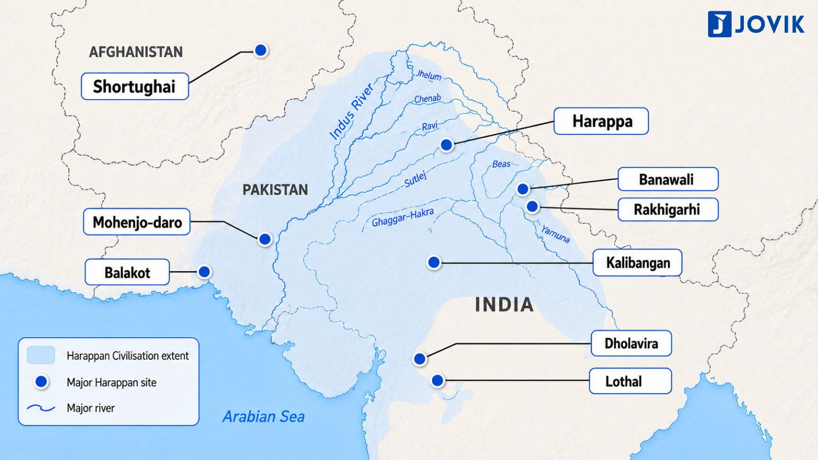
Different regions produced different goods and had different local features. This regional variation within a shared cultural framework is itself an important characteristic of the civilisation.
4. Town Planning and Urban Layout
The Harappans were building planned cities with covered drains more than four thousand years ago. At that time, most other parts of the world had simple villages or unplanned settlements. The level of urban planning seen in Harappan cities was extraordinary for its time. It is the single most important achievement of this civilisation.
Citadel and Lower Town
Every major Harappan city was divided into two clearly separate parts. The first part was called the citadel, a raised platform located on the western side of the city. Important public buildings were located here. The second part was the lower town, on the eastern side. It was larger than the citadel and contained the houses where most people lived, along with craft workshops and market areas.
Both the citadel and the lower town were surrounded by protective walls. [NDA 2011-II] This is a detail that NDA has tested. Students often assume only the citadel was walled because it was the important part of the city. Both parts were walled.
Grid Pattern
The streets of Harappan cities followed a grid pattern. The main streets ran straight from north to south and from east to west. Smaller lanes branched off at right angles. This created a neat and orderly layout across the entire city.
Standardised Bricks
The Harappans used standardised baked bricks across all their cities. The bricks followed the same size ratio of 1:2:4 at sites hundreds of kilometres apart. This consistency across such a large geographic area suggests that some central authority or shared system of standards was operating across all Harappan settlements.
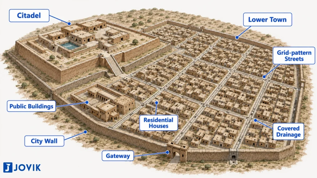
| Feature | Detail |
| City division | Citadel (west, elevated) and lower town (east, larger) |
| Walls | Both citadel and lower town walled [NDA 2011-II] |
| Street pattern | Grid plan : north-south and east-west |
| Building material | Standardised baked and unbaked mud bricks |
| Brick size ratio | Consistent 1:2:4 ratio across all sites |
5. The Great Bath
The most famous structure found in any Harappan city is the Great Bath at Mohenjo-daro. Its design and location tell us something important about how the Harappans organised their public and possibly their religious life.
Structure and Location
The Great Bath is located on the citadel at Mohenjo-daro. Its position on the elevated and protected part of the city tells us immediately that this was not an ordinary facility.
The tank measured approximately twelve metres in length, seven metres in width, and nearly two and a half metres in depth. The floor and sides were built with tightly fitted baked bricks. A layer of natural tar was applied between the bricks to make the structure completely watertight. Steps led down into the tank from both the northern and southern ends. Changing rooms and galleries surrounded the tank on all sides.
Water Supply
The water supply for the Great Bath came from a large well located in an adjoining room on the eastern side of the structure. [NDA 2026-I] Used water drained out through a large corbelled drain built into the corner of the tank.
Students often place the well on the western side because the citadel itself is on the western side of the city. That reasoning is incorrect. The well was on the eastern side of the Great Bath structure. [NDA 2026-I]
Purpose
Historians believe the Great Bath was used for ritual bathing: bathing for religious purification rather than everyday cleanliness. This conclusion is supported by the structure’s careful construction and its prominent location on the citadel. Because the Harappan script is undeciphered, there is no written evidence to confirm this. It remains a reasonable interpretation based on physical evidence alone.
6. Houses, Streets, and Drainage
The planning of Harappan cities was not limited to public structures. It extended to every house, every street, and every drain. The entire city, from the largest public building down to the smallest residential lane, formed one connected and organised system.
House Layout
Harappan houses were built around a central courtyard. The rooms of the house opened inward onto this courtyard. Doorways and windows generally faced the side lanes rather than the main streets. [NDA 2011-II] This design gave residents privacy from the activity on the main roads.
Most houses had a separate bathing area. Waste water from the bathing area flowed through a drain built into the wall and connected to the street drain outside. Some larger houses had water chutes built inside the walls to carry water down from an upper floor. [NDA 2011-II] This is evidence that some Harappan houses had more than one storey.
The Drainage System
Every house drain connected to a larger drain running along the street. These street drains were covered with brick slabs or stone. The covers could be lifted for regular cleaning and maintenance. Drains ran along all major streets and lanes and carried waste water away efficiently.
| Feature | Detail |
| House layout | Built around a central courtyard |
| Doors and windows | Faced side lanes, rarely the main street [NDA 2011-II] |
| Bathing area | Separate bathing area in most houses |
| Internal drainage | House drains built into walls, connected to street drains |
| Upper floor drainage | Water chutes built inside walls [NDA 2011-II] |
| Street drains | Covered with removable brick slabs for cleaning |
| ★ IMPORTANT: No other ancient civilisation of this period had a citywide covered drainage network of this scale. Egypt had none. Mesopotamia had none. The Harappan drainage system is direct evidence that public cleanliness was a civic priority and that maintaining the city required a functioning civic authority. |
7. Agriculture and the Economy
The Harappan Civilisation was not just about cities and drains. It had a strong agricultural base that supported its large urban population. Without organised farming, cities of this size could not have existed.
The Harappans grew a variety of crops. Wheat and barley were the most important food crops. They also grew cotton, particularly significant because the Harappans were among the earliest people in the world to grow and use cotton for making cloth.
Evidence of the Plough
One of the most important agricultural discoveries is the evidence of ploughing. The Harappans used a plough to prepare their fields for farming. We know this from two types of evidence.
The first is physical models. Terracotta models of the plough have been found at Banawali in Haryana [NDA 2012-I] and at sites in Cholistan in Pakistan. [NDA 2023-II]
The second is a ploughed field itself. At Kalibangan in Rajasthan, archaeologists found the remains of an actual ploughed field. The field showed two sets of furrows crossing each other at right angles. [NDA 2023-II] This pattern suggests that two different crops were grown together in the same field, an early example of a farming technique still used in parts of India today.
A detail that NDA has tested directly: the ploughed field at Kalibangan belongs to the Early Harappan phase, not the Mature Harappan phase. [NDA 2023-II] Students frequently assume it belongs to the Mature phase because that is the peak period of the civilisation. It does not.
| Agricultural Evidence | Site | Detail |
| Terracotta plough model | Banawali, Haryana | Physical model of a plough [NDA 2012-I] |
| Terracotta plough model | Cholistan, Pakistan | Additional plough model evidence [NDA 2023-II] |
| Ploughed field | Kalibangan, Rajasthan | Two sets of furrows at right angles. Early Harappan phase. [NDA 2023-II] |
8. Craft Production and Specialisation
The Harappan economy was not based on farming alone. It also had a highly developed craft industry. Different sites specialised in producing different goods. This specialisation is evidence that the Harappan economy was organised and that goods were being exchanged between sites across the civilisation.
Bead Production
Bead making was one of the most important Harappan crafts. Harappan beads were made from several different materials: carnelian, quartz, and steatite. [NDA 2026-I] The beads came in different shapes: cylindrical, barrel-shaped, and disc-shaped forms. [NDA 2026-I]
Making these beads required skill and specialised tools. Archaeologists have found specialised stone drills at Harappan sites. [NDA 2026-I] These drills were used to make the tiny holes through which a thread was passed.
| Bead Feature | Detail |
| Materials used | Carnelian, quartz, steatite [NDA 2026-I] |
| Shapes | Cylindrical, barrel-shaped, disc-shaped [NDA 2026-I] |
| Tool used | Specialised stone drills [NDA 2026-I] |
Shell Object Production
The site of Balakot in Balochistan, Pakistan, was a specialised centre for making shell objects. [NDA 2021-I] This kind of site specialisation shows that the Harappan economy had moved beyond simple self-sufficiency. Different communities produced specific goods and exchanged them with others.
Standardisation and State Control
The scholar Kenoyer argued that the consistency of Harappan crafts across hundreds of sites was the result of State control. [NDA 2015-I] According to Kenoyer, a central authority regulated craft production across the civilisation and maintained standards for weights, measures, brick sizes, and craft quality. The standardisation was not accidental or informal. It reflected deliberate central oversight.
9. Seals and the Writing System
If there is one object that represents the Harappan Civilisation more than any other, it is the seal. Thousands of seals have been found at Harappan sites. They carry images and inscriptions that give us information about Harappan trade, administration, and belief. For NDA students, seals are among the most frequently tested topics in this chapter.
What Did the Seals Look Like?
Harappan seals were square or rectangular in shape. They were made of steatite (soapstone). [NDA 2025-I] The surface of the seal was carved with images of animals: the humped bull, elephant, rhinoceros, or tiger. Below the image, a short inscription was carved in the Harappan script.
Here is a comparison that NDA has tested directly. Seals used in Mesopotamia were cylindrical in shape. Harappan seals were not cylindrical. They were square or rectangular. [NDA 2016-II]
| Feature | Harappan Seals | Mesopotamian Seals |
| Shape | Square or rectangular [NDA 2016-II] | Cylindrical |
| Material | Steatite (soapstone) [NDA 2025-I] | Stone or clay |
| Use | Trade, administration | Trade, administration |
What Were Seals Used For?
Seals were practical objects. A trader would press a seal into soft clay to create an impression, identifying the owner of the goods and helping regulate trade. Seals found at sites outside the Harappan world, including in Mesopotamia, are direct evidence of contact between the two civilisations.
The Harappan Script
The inscriptions on the seals are written in the Harappan script. This script has around four hundred signs. It has not been deciphered. As a result, historians cannot read the inscriptions. Everything about Harappan administration and trade organisation is inferred from the physical evidence of the seals themselves, not from their written content.
10. Trade and External Contacts
The Harappans were not an isolated civilisation. They traded with people far beyond their own territory. This external trade shows that the ancient world was far more connected than most students expect.
Trade with Mesopotamia
The clearest evidence of long-distance trade comes from the connection with Mesopotamia, the ancient civilisation located in present-day Iraq. Harappan seals have been found at Mesopotamian sites. Mesopotamian records also mention a distant land called Meluha. Historians have identified Meluha as the Harappan region. [NDA 2017-II]
Evidence at Shortughai
The northernmost known Harappan site is Shortughai in present-day Afghanistan. Traces of canals have been found here. [NDA 2025-II] The presence of a Harappan settlement this far north shows how wide the trading network of the civilisation actually was.
| Trade Evidence | Site or Source | Detail |
| Harappan seals found abroad | Mesopotamian sites | Direct evidence of contact |
| Term Meluha | Mesopotamian records | Name used for the Harappan region [NDA 2017-II] |
| Canal traces | Shortughai, Afghanistan | Northernmost Harappan site [NDA 2025-II] |
| Dockyard | Lothal, Gujarat | Evidence of sea trade |
What Did They Trade?
The Harappans likely exported goods such as cotton textiles, beads, ivory, and timber. In return, they imported metals and other materials not available locally. The existence of a dockyard at Lothal in Gujarat is evidence that some of this trade was conducted by sea.
11. Religion and Ritual Life
Religion is one of the most discussed topics in Harappan studies. It is also one of the most uncertain. Because the Harappan script is undeciphered, there are no religious texts, no hymns, and no confirmed names of gods or rituals. Everything in this section is interpretation based on physical evidence.
| Physical Evidence | Site | Tentative Interpretation |
| Fire altars | Kalibangan [NDA 2022-II] | Fire rituals or sacrificial practices |
| Great Bath | Mohenjo-daro | Ritual bathing for purification |
| Female figurines | Multiple sites | Possible mother goddess worship |
| Seated figure on seal | Mohenjo-daro | Possible proto-Shiva figure |
Fire altars have been found at Kalibangan in Rajasthan. [NDA 2022-II] These are brick-lined pits that show signs of burning.
The Great Bath at Mohenjo-daro, with its prominent position on the citadel and careful waterproofing, suggests it was used for ritual bathing rather than everyday purposes.
Figurines have been found at multiple sites. Many are female figures, associated by some historians with a mother goddess or fertility cult. One seal from Mohenjo-daro shows a figure seated in a yoga-like posture surrounded by animals. Some historians have called this a proto-Shiva figure, though this interpretation is not universally accepted.
| ★ IMPORTANT: When answering questions about Harappan religion, always look for what the physical evidence actually shows rather than what later historians have assumed. All religious conclusions are tentative interpretations. No temple has been conclusively identified. No deity has been confirmed by name. |
12. Decline of the Civilisation
Around 1900 BCE, the great Harappan cities began to decline. Streets were no longer maintained. Drains fell into disrepair. Trade reduced. People began moving away. By around 1300 BCE, the urban phase of the civilisation had effectively ended.
| Theory | What It Argues | Supporting Evidence |
| Aryan Invasion | Aryans invaded from outside and destroyed Harappan cities | Skeletal remains at Mohenjo-daro showing signs of violence: later found to be inconclusive |
| Climate Change and Drought | Reduced rainfall weakened agriculture and the food supply | Geological and pollen evidence of reduced monsoon rainfall after 2000 BCE |
| River Course Changes | The Ghaggar-Hakra dried up or changed course | Many major sites located along its dried bed |
| Flooding | Repeated flooding destroyed cities, particularly Mohenjo-daro | Archaeological evidence of flood deposits at Mohenjo-daro |
| Internal Decline | Trade networks broke down, administrative systems weakened | Evidence of reduced quality in later Harappan construction and craft production |
| ★ IMPORTANT: Modern historians do not support the Aryan invasion theory as the primary cause. Current scholarship favours a combination of causes: climate change, river course changes, and internal weakening of trade and administration working together over several centuries. The decline was not sudden and not uniform across the civilisation. |
JOVIK QUICK RECALL
DISCOVERY – Harappa discovered 1921: Daya Ram Sahni – Mohenjo-daro discovered 1922: Rakhal Das Banerji – John Marshall announced the civilisation : 1924 – Named Harappan after the first site discovered
EXTENT – Spread across India, Pakistan, and Afghanistan – Matured in Sind and Punjab → spread southwards and eastwards [NDA 2014-II] – Total area larger than ancient Egypt and Mesopotamia combined [NDA 2014-II]
SOURCES AND DATING – Primary method: archaeological excavation – Dating method: radiocarbon dating using carbon-14 – Harappan script: undeciphered. No written records available. – All religious and political interpretations are tentative
PHASES – Early Harappan: 3200 BCE to 2600 BCE – Mature Harappan: 2600 BCE to 1900 BCE – Late Harappan / Decline: 1900 BCE to 1300 BCE
MAJOR SITES
| Site | Location | Key Finding |
| Harappa | Punjab, Pakistan | First site discovered |
| Mohenjo–daro | Sindh, Pakistan | Great Bath |
| Kalibangan | Rajasthan, India | Fire altars. Ploughed field (Early Harappan) |
| Banawali | Haryana, India | Terracotta plough model |
| Lothal | Gujarat, India | Dockyard |
| Balakot | Balochistan, Pakistan | Shell object production |
| Shortughai | Afghanistan | Canal traces. Northernmost site |
| Dholavira | Gujarat, India | Water reservoir. Script signboard |
| Cholistan | Pakistan | Terracotta plough models |
TOWN PLANNING – Cities divided into citadel (west, elevated) and lower town (east, larger) – Both citadel and lower town were walled [NDA 2011-II] – Streets followed a grid pattern : north-south and east-west – Standardised baked bricks : size ratio 1:2:4 across all sites
THE GREAT BATH – Located on the citadel at Mohenjo-daro – Made watertight with tar between bricks – Water supply from a well on the EASTERN side [NDA 2026-I] – Purpose : likely ritual bathing. Interpretation only, not confirmed.
HOUSES AND DRAINAGE – Houses built around a central courtyard – Doors and windows faced side lanes, NOT main streets [NDA 2011-II] – Separate bathing areas in most houses – Water chutes inside walls for upper floor drainage [NDA 2011-II] – All house drains connected to covered street drains
AGRICULTURE – Main crops : wheat, barley, cotton – Terracotta plough models : Banawali [NDA 2012-I] and Cholistan [NDA 2023-II] – Ploughed field at Kalibangan : two sets of furrows at right angles [NDA 2023-II] – Kalibangan ploughed field : EARLY Harappan phase. NOT Mature phase [NDA 2023-II]
CRAFT PRODUCTION – Bead materials : carnelian, quartz, steatite [NDA 2026-I] – Bead shapes : cylindrical, barrel-shaped, disc-shaped [NDA 2026-I] – Tool used : specialised stone drills [NDA 2026-I] – Balakot : specialised centre for shell objects [NDA 2021-I] – Kenoyer : standardisation due to State control [NDA 2015-I]
SEALS – Shape : square or rectangular [NDA 2016-II] – Material : steatite (soapstone) [NDA 2025-I] – Used for trade and administration – Mesopotamian seals were cylindrical. NOT Harappan [NDA 2016-II] – Harappan script on seals : undeciphered
TRADE AND EXTERNAL CONTACTS – Mesopotamian records used the term Meluha for the Harappan region [NDA 2017-II] – Canal traces found at Shortughai in Afghanistan [NDA 2025-II] – Dockyard at Lothal : evidence of sea trade – Exports : cotton textiles, beads, ivory, timber
RELIGION – Fire altars found at Kalibangan [NDA 2022-II] – Great Bath at Mohenjo-daro : likely used for ritual bathing – Female figurines : possible mother goddess worship – Seated figure on seal : possible proto-Shiva. Not confirmed. – No temple conclusively identified. No deity confirmed by name. – All religious conclusions are tentative interpretations
DECLINE – Began around 1900 BCE. Urban phase ended by 1300 BCE. – Main theories : Aryan invasion, climate change, river course changes, flooding, internal decline – Aryan invasion theory NOT accepted by modern historians – Current view : gradual decline caused by multiple factors together