Free NDA 2026 Preparation Guide
View Strategy

India’s Coastal Geography
Coastal States, Gulfs, Straits, Islands and Maritime Zones of India
Indian Geography • Coastal Geography • PYQs Included
Introduction
India has a 7,516 km coastline that touches nine states and four Union Territories on the eastern and western coasts. In NDA and CDS exams, Questions test which state has the longest coastline; the names and locations of gulfs and straits; channels between island groups; maritime neighbours; and territorial sea limits.
Understand the Topic
The coastline, its states, and the waters around India
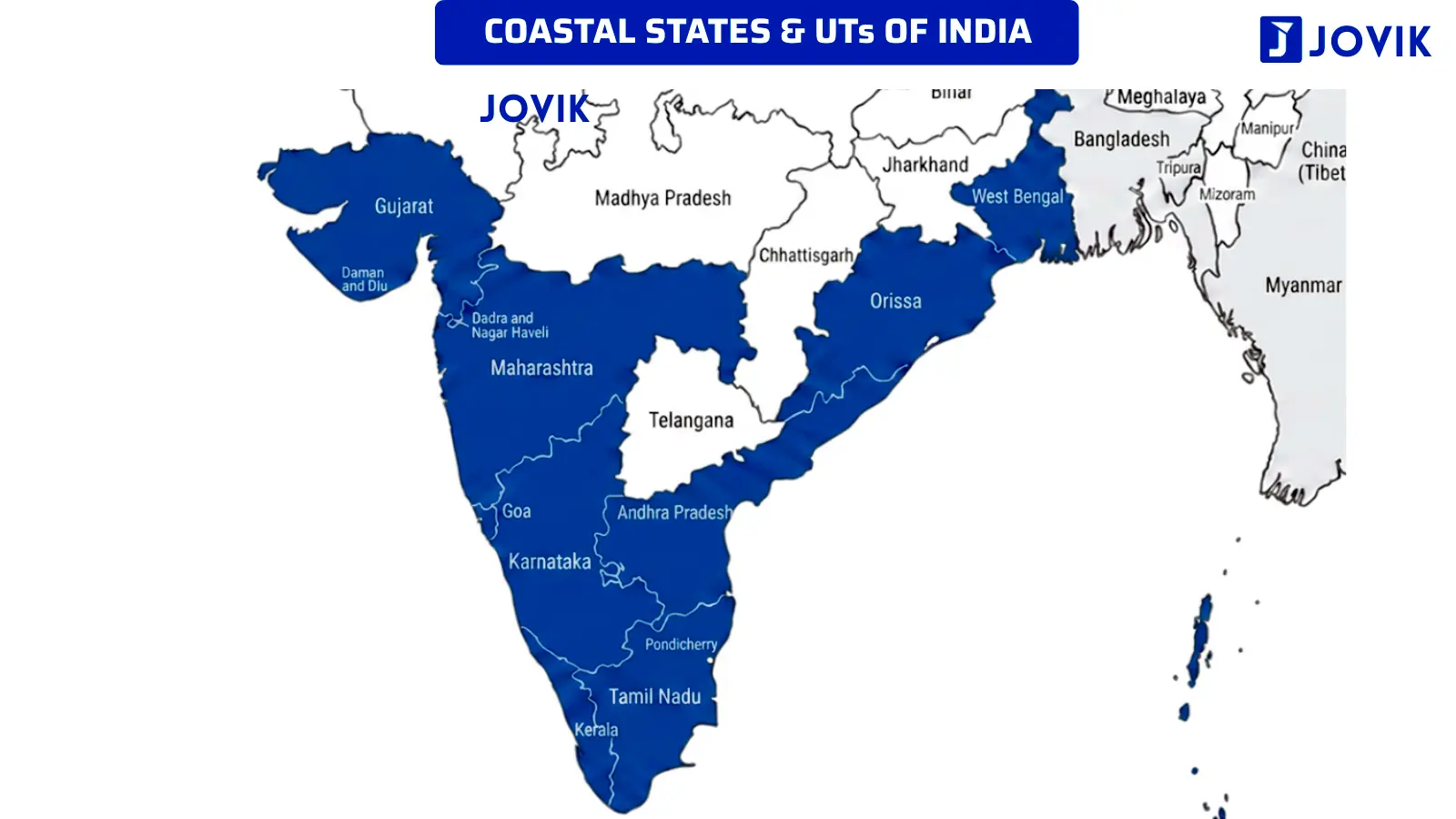
India’s peninsula is shaped like a broad triangle pointing southward. The Arabian Sea bounds it to the west, the Bay of Bengal to the east, and the Indian Ocean is at the tip of the peninsula. Due to the triangular form, India is blessed with two distinct coasts: a western coast and an eastern coast. Both coasts have their own characteristics and their own geographical features. Some states in India lie on the eastern coast, and others on the western coast.
India has the longest coastline in the Indian Ocean. The total length of the coastline is approximately 7,516 km.
There are a total of nine states and four Union Territories that are on the two sides of the Indian peninsula:
States on the Western Coast — Arabian Sea
- Gujarat
- Maharashtra
- Goa
- Karnataka
- Kerala
States on the Eastern Coast — Bay of Bengal
- Tamil Nadu
- Andhra Pradesh
- Odisha
- West Bengal
List of the four coastal Union Territories:
UT on the Western Coast — Arabian Sea
1. Dadra and Nagar Haveli and Daman and Diu
2. Lakshadweep
UT on the Eastern Coast — Bay of Bengal
1. Puducherry, and
2. The Andaman and Nicobar Islands
Coastline length ranking
Among all the coastal states, Gujarat has the longest coastline due to its irregular, heavily indented shoreline. Andhra Pradesh and Tamil Nadu are ranked second and third.
Apart from the coastline, India’s peninsula is bordered by several important enclosed or semi-enclosed water bodies, such as gulfs, straits, and channels.
Longest to Shortest ranking of border lengths (States):
|
# |
State |
Length |
Type |
|---|---|---|---|
|
1 |
Gujarat |
2,340.62 |
Longest among states |
|
2 |
Tamil Nadu |
1,068.69 |
2nd longest among states |
|
3 |
Andhra Pradesh |
1,053.07 |
|
|
4 |
Maharashtra |
877.97 |
|
|
5 |
West Bengal |
721.02 |
|
|
6 |
Kerala |
600.15 |
|
|
7 |
Odisha |
574.71 |
|
|
8 |
Karnataka |
343.30 |
|
|
9 |
Goa |
193.95 |
Shortest among States |
Longest to Shortest ranking of border lengths (States & UTs):
|
# |
State |
Length |
Type |
|---|---|---|---|
|
1 |
Andaman & Nicobar Islands |
3,083.50 |
Longest among states & UTs |
|
2 |
Gujarat |
2,340.62 |
2nd longest among states |
|
3 |
Tamil Nadu |
1,068.69 |
|
|
4 |
Andhra Pradesh |
1,053.07 |
|
|
5 |
Maharashtra |
877.97 |
|
|
6 |
West Bengal |
721.02 |
|
|
7 |
Kerala |
600.15 |
|
|
8 |
Odisha |
574.71 |
|
|
9 |
Karnataka |
343.30 |
Shortest among States |
|
10 |
Goa |
193.95 |
|
|
11 |
Lakshadweep Islands |
144.80 |
|
|
12 |
Daman & Diu |
54.38 |
|
|
13 |
Puducherry |
42.65 |
There is no need to remember the coastal length of the states. It is only given for reference and clarity. Only remember the length order.
Gulfs around India
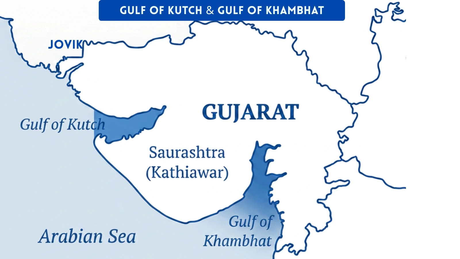
Three gulfs border the coast of India. Each one is formed by a different geographic configuration and has its own importance.
Gulf of Kutch
It is located on the western edge of Gujarat, near the Kutch district. The surrounding area is marshy and arid.
Gulf of Khambhat (Cambay)
A narrow arm of the Arabian Sea on the south-eastern coast of Gujarat. It is at the mouths of the Narmada and Tapti rivers. Both rivers drain into the Gulf of Khambhat. The funnel shape of the gulf creates high tidal ranges.
Gulf of Mannar
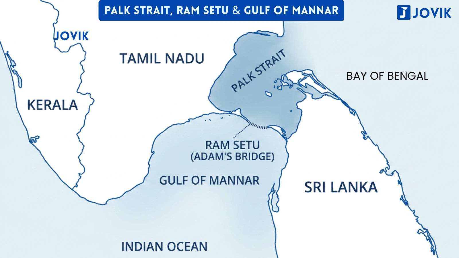
It lies between southern Tamil Nadu and the north-western coast of Sri Lanka. It forms the southern part of the narrow sea separating India and Sri Lanka. The Palk Strait connects the Gulf of Mannar to the Bay of Bengal to the north. Ram Setu (Adam’s Bridge) is a chain of limestone shoals that forms the boundary between them.
Palk Strait
A narrow strip of water between south-eastern India (Tamil Nadu) and north-western Sri Lanka. It connects the Bay of Bengal in the north to the Gulf of Mannar in the south. Ram Setu (Adam’s Bridge), a natural chain of limestone shoals, separates the Palk Strait from the Gulf of Mannar. This is the principal waterway that separates India from Sri Lanka.
Palk Strait vs Gulf of Mannar:
These two are adjacent but distinct. The Palk Strait is to the north, and it connects the Bay of Bengal to the Gulf of Mannar. The Gulf of Mannar lies to the south and opens into the Indian Ocean. Ram Setu marks the boundary between them.
Maritime neighbours of India
India’s maritime boundaries are shared with seven countries:
|
# |
State |
|---|---|
|
1. |
Pakistan |
|
2. |
Maldives |
|
3. |
Sri Lanka |
|
4. |
Bangladesh |
|
5. |
Myanmar |
|
6. |
Thailand |
|
7. |
Indonesia |
Territorial Limit of India
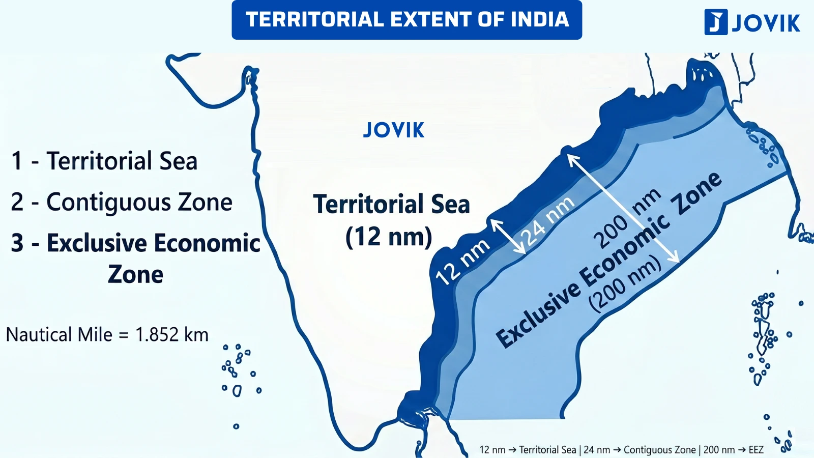
Beyond the visible coastline, India’s sovereign territory extends further into the sea, as defined by international maritime law under UNCLOS III.
India’s territorial sea extends up to 12 nautical miles from the coastline (Check Image). Within this zone, India has complete sovereign rights, the same as over its land territory.
STATUTE MILE
~1.6 km
= 63,360 inches
Used on Land
NAUTICAL MILE
~1.852 km
= 6,080 feet = 72,960 inches
Used at sea
Territorial sea = 12 nautical miles from the coastline.
India’s southernmost maritime boundary extends to 6° 45′ N latitude in the Bay of Bengal.
Memory Trick to remember the States name
G-T-A-M-W-K-O-K-G
Gujarat – Tamil Nadu – Andhra Pradesh – Maharashtra – West Bengal – Kerala – Odisha – Karnataka – Goa
G T A M W K O K G — “Great Teachers Always Make Wonderful Knowledge Of Kind Goodness.”
Previous Year Questions
Q1. The Gulf of Mannar is situated along the coast of: [NDA 2011-II]
- Tamil Nadu
- Kerala
- Karnataka
- Andhra Pradesh
Answer: (A) Tamil Nadu
Explanation: The Gulf of Mannar lies between the southern tip of Tamil Nadu and the north-western coast of Sri Lanka. It is completely on the south-eastern side of the peninsula. Kerala and Karnataka are on the west coast. Neither state borders Sri Lanka nor the Gulf of Mannar. Andhra Pradesh is farther north on the east coast, farther from the Gulf. So, Tamil Nadu is the correct choice.
Q2. Which one of the following states in India has the longest coastline? [NDA 2017-II]
- Odisha
- Tamil Nadu
- Karnataka
- West Benal
Answer: (B) Tamil Nadu
Explanation: Gujarat has the longest coastline among states, but it is not one of the options. Among the four given options, Tamil Nadu has the longest coastline (~1068 km). Candidates should always check the full list of options.