Free NDA 2026 Preparation Guide
View Strategy

India: Location, Extent & Neighbours
Learn why 82°30′E was selected as India’s Standard Meridian, how Indian Standard Time (IST) is calculated, and its importance in Geography and defence exams.
Indian Geography • Time & Longitude Concepts • PYQs Included
Introduction
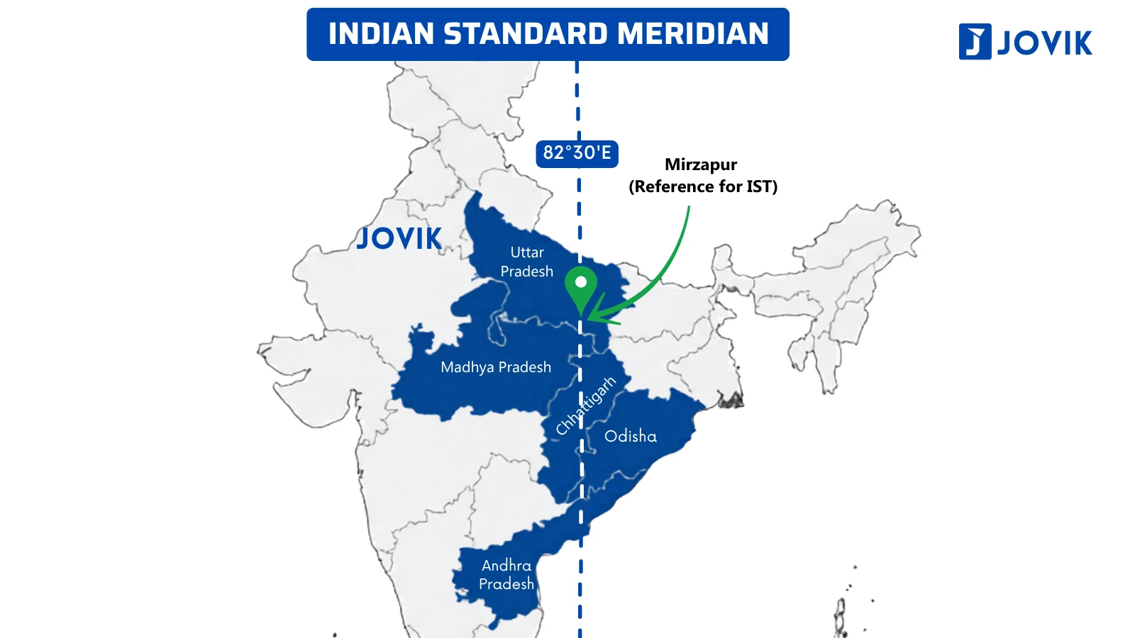
India follows a single time zone. The Indian Time Zone is based on the 82½° E meridian. The 82½° E meridian passes through five states of India: Uttar Pradesh, Madhya Pradesh, Chhattisgarh, Odisha and Andhra Pradesh.
IIn NDA and CDS exams, questions are asked about the 82½° E meridian by changing its figure, stating the meridian it passes through, and the difference between Greenwich Mean Time (GMT) and Indian Standard Time (IST).
Read the whole article carefully and then solve the PYQs given at the end of the article; you will be able to solve all the probable questions related to the chapter.
Understand the topic
Indian Standard Meridian
What is the standard meridian?
The Standard Meridian of a country is the line chosen to maintain a uniform time throughout the country. In India’s case, the meridian is 82½° E.
The longitude (vertical lines) chosen by a country to maintain a uniform standard time throughout the country.
We can draw two types of imaginary lines on the globe: horizontal lines called latitudes and vertical lines called longitudes or Meridians.
In the case of latitude, we take the equator as 0° for reference. Similarly, we take the Greenwich Line as 0° longitude. The purpose of this line is to create a proper system of time across the earth.
Why does every country need a standard meridian?
The sun rises in eastern India, specifically in Arunachal Pradesh. Now, imagine that as the sun moves from the eastern to the western side of India, it keeps covering a different degree at each place; there are different times at each place. Imagine Itanagar (the capital of Arunachal) has a different time, Kolkata has a different time, Ranchi has a different time, and so on.
So, as the sun moves from east to west, it creates a continually changing solar time at each location in the world and in a country.
A country that spans multiple longitudes will face confusion if every city uses its own local time. Train schedules, communications systems, and administration will become very challenging to manage.
That’s why to solve this issue, a country picks a single longitude as its Standard Meridian and, based on that, calculates a uniform time throughout the country. This chosen longitude or meridian is called the Standard meridian.
The Time at Greenwich Mean Time is considered 0. So, the time difference from Greenwich Mean Time is called that country’s Standard Time. This time applies nationwide, regardless of local solar variation.
Why was only 82½° E chosen as the standard time for India?
India’s Westernmost point is at 68° E, Guhar Moti is in Gujarat, and its easternmost point is Kibithu in 97° E, which is in Arunachal Pradesh.
If we calculate the difference between the two extreme points, it will be around 30°.
So, a standard meridian had to be chosen near the middle of the Easternmost and Westernmost points.
And that middle was found on the 82½° E meridian.
How is IST calculated? The logic behind IST = GMT + 5:30
Since
1° of longitude = 4 minutes; the offset for any meridian from GMT (0°) is simply its longitude multiplied by 4.
Earth’s rate: 360° in 24 hours → 15° per hour → 1° per 4 minutes
ISM longitude 82.5° × 4 minutes = 330 minutes
330 minutes = 5 hours 30 minutes → IST = GMT + 5:30
This calculation also explains why NDA asks questions about east-west sunrise differences. Arunachal Pradesh (97° E) is about 29° east of Gujarat (68° E), which means roughly 29 × 4 = 116 minutes≈ , or 2 hours of difference. The Sun rises about 2 hours earlier in eastern India than in the west.
The 5 states on the Indian Standard Meridian
The 82½° E meridian passes through 5 Indian states. The names of the states, as well as the sequence, are extremely important to remember. As it is one of the most asked questions in the exams.
Map Reference: Indian Standard Meridian Through India
Longest to Shortest ranking of border lengths:
|
# |
Country |
|---|---|
|
1. |
Uttar Pradesh |
|
2. |
Madhya Pradesh |
|
3. |
Chhattisgarh |
|
4. |
Odisha |
|
5. |
Andhra Pradesh |
States do not fall on the Indian Standard Meridian: Obviously, many do not align with ISM, but some states are confusing and are often asked as options in the exam. So, take care of them. The states are Uttarakhand, Jharkhand, Telangana, and Tamil Nadu.
Why does India have a single time zone?
France has 12 time zones. The United States of America and Russia also have 11 time zones each.
India has a 2-hour local solar time difference between its easternmost and westernmost points. Still, India uses a single time zone for the entire country. It means every part of India will have the same or uniform time.
This is mainly due to administrative reasons. If India adopts multiple time zones, there will be complete chaos or confusion in railways and other areas. Even the Andaman and Nicobar Islands and the Lakshadweep Islands also follow the same Standard Time.
Four states/UTs of India border a total of three different countries, the exact number that the CDS 2020-I directly asked students to identify when questioning them regarding the number of states that bordered more than two countries. The infographic shows the international borders of each Indian state, Union Territory (UT) or area adjacent to India. Thus, the international boundaries for Ladakh, Sikkim, West Bengal, and Arunachal Pradesh are at the borders with Pakistan, Afghanistan, China, Nepal, Bhutan, and Myanmar, respectively.
Tropic of Cancer
What is the Tropic of Cancer?
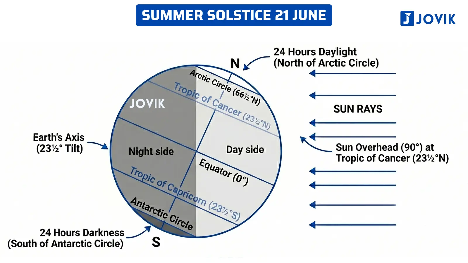
The Tropic of Cancer is an imaginary line of latitude at 23½° N. It is the northernmost point where the Sun can appear directly overhead at noon. This happens around 21 June (Summer Solstice) every year.
Why Does the Tropic of Cancer Exist?
Earth’s Tilt: The Earth is tilted by 23½° on its axis. Because of this tilt, different parts of the Earth receive different amounts of sunlight during the year.
Shifting Position of the Sun: Due to the Earth’s tilt and revolution around the Sun, the Sun’s direct rays shift between the Tropic of Cancer (23½° N) and the Tropic of Capricorn (23½° S).
Northernmost Overhead Position: Around 21 June (Summer Solstice), the Sun appears directly overhead at the Tropic of Cancer. This is the northernmost point where this happens.
The areas south of the Tropic of Cancer receive the overhead Sun during the year and are considered tropical regions. On the other hand, areas north of the Tropic of Cancer never receive overhead Sun and are subtropical.
Concept Diagram: Summer Solstice and Tropic of Cancer
Tropic of Cancer in India
The Tropic of Cancer passes through India from the west coast of Gujarat and exits at the northeastern state of Mizoram. So, it passes through eight states of India:
|
# |
State |
Important Fact |
Type |
|---|---|---|---|
|
1. |
Gujarat |
Coastal |
|
|
2. |
Rajasthan |
Shortest Length |
Landlocked |
|
3. |
Madhya Pradesh |
Longest Length |
Landlocked |
|
4. |
Chattisgarh |
Landlocked |
|
|
5. |
Jharkhand |
Landlocked |
|
|
6. |
West Bengal |
Coastal |
|
|
7. |
Tripura |
Landlocked |
|
|
8. |
Mizoram |
Landlocked |
Remember these states in exact order because the NDA and CDS exams often ask questions about east-to-west or west-to-east arrangements.
Map Reference: Tropic of Cancer Through India
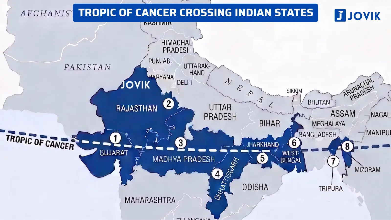
The Tropic of Cancer runs almost through the middle of India; therefore, India is located in both the tropical and subtropical climatic zones.
Other Important Points
The Bangladesh gap: The Tropic of Cancer does not travel in a straight line throughout India. Between West Bengal and Tripura, it passes through Bangladesh.
Mahi River: The Mahi River originates in Madhya Pradesh. It flows into Rajasthan and then turns to Gujarat and ends its course in the Arabian Sea. It follows an S-shaped path, and due to this, the Tropic of Cancer crosses the Mahi River twice, once in Madhya Pradesh and once in Gujarat.
Ranchi: Ranchi is the capital of the Jharkhand state. It is the only state capital that lies on the Tropic of Cancer.
Land Neighbours of India & Bordering States
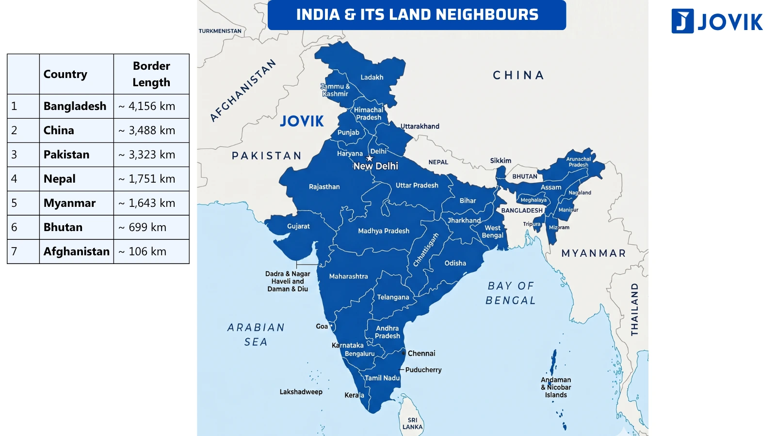
India’s land borders
Only a few countries in the world share land borders with as many as 7 nations. Out of India’s borders with these seven countries, each has different types of geographic features along the Indian border. For example, there are features of landforms in the mountainous areas of northern India (the Himalayas), the rivers and flatlands (the Ganges River and the Great Plains) in eastern India, and the desert of western India (Thar Desert), plus many different political and national boundaries throughout each of these features.
The key question on which the examiners of the NDA and CDS focus is which of the seven nations/Indian States borders the most Indian States, and the total distance each of the seven nations has of land border(s) with India. One piece of information that is likely to be a surprise to many students is that Bangladesh’s land border with India is longer than the land borders of China and Pakistan.
Longest to Shortest ranking of border lengths:
|
# |
Country |
Length |
|---|---|---|
|
1. |
Bangladesh |
~ 4,156 km |
|
2. |
China |
~3,488 km |
|
3. |
Pakistan |
~3,323 km |
|
4. |
Nepal |
~1,751 km |
|
5. |
Myanmar |
~1,643 km |
|
6. |
Bhutan |
~699 km |
|
7. |
Afghanistan |
~106 km |
Buffer states:
Nepal and Bhutan are both buffer states because they are located between India and China and serve as barrier states. Buffer states are those regions situated between the borders of two powerful rivals and can reduce the risk of armed conflict between them. As a result of this geographic function, their strategic value extends beyond their size.
Map Reference: India and Its Land Neighbours
Longest to Shortest ranking of border lengths:
|
# |
Country |
Count |
States / UTs on the border |
|---|---|---|---|
|
1. |
Bangladesh |
1 UT |
Ladakh |
|
2. |
China |
2 UTs + 3 States |
Ladakh, Jammu & Kashmir, Punjab, Rajasthan, Gujarat |
|
3. |
Pakistan |
1 UT + 4 States |
Ladakh, Himachal Pradesh, Uttarakhand, Sikkim, Arunachal Pradesh |
|
4. |
Nepal |
5 States |
Uttarakhand, Uttar Pradesh, Bihar, West Bengal, Sikkim |
|
5. |
Myanmar |
4 States |
Sikkim, West Bengal, Assam, Arunachal Pradesh |
|
6. |
Bhutan |
5 States |
West Bengal, Assam, Meghalaya, Tripura, Mizoram |
|
7. |
Afghanistan |
4 States |
Arunachal Pradesh, Nagaland, Manipur, Mizoram |
States and UTs that border three countries
|
# |
Country |
Count |
|---|---|---|
|
1. |
Ladakh |
Pakistan · Afghanistan · China |
|
2. |
Sikkim |
Nepal · China · Bhutan |
|
3. |
West Bengal |
Nepal · Bhutan · Bangladesh |
|
4. |
Arunachal Pradesh |
China · Bhutan · Myanmar |
Ladakh is the only territory of India that shares borders with three different countries: Pakistan, Afghanistan, and China. While there is no other state or Union Territory within India that has a border with Afghanistan at this time, all of Afghanistan’s land borders are completely shared with Ladakh.
Special Cases
Tripura: Tripura is surrounded on three sides by Bangladesh, with connection only by a narrow corridor of land into India from the east through Assam and Mizoram.
Uttar Pradesh: It shares boundaries with more states and Union Territories (9 states/UTs): Uttarakhand, Himachal Pradesh, Haryana, Delhi, Rajasthan, Madhya Pradesh, Chhattisgarh, Jharkhand and Bihar.
States with no international border and no coastline: Haryana, Madhya Pradesh, Chhattisgarh, Jharkhand, and Telangana have no international boundary and no sea coast.
Four states/UTs of India border a total of three different countries, the exact number that the CDS 2020-I directly asked students to identify when questioning them regarding the number of states that bordered more than two countries. The infographic shows the international borders of each Indian state, Union Territory (UT) or area adjacent to India. Thus, the international boundaries for Ladakh, Sikkim, West Bengal and Arunachal Pradesh are at the borders with Pakistan, Afghanistan, China, Nepal, Bhutan, and Myanmar, respectively.
Telangana and Madhya Pradesh — Frequently asked
Questions from Two states, Telangana and Madhya Pradesh, come up repeatedly in PYQs. Both have no international borders and are entirely landlocked states.
|
# |
Country |
Count |
Neighbouring states |
|---|---|---|---|
|
1. |
Telangana |
5 |
Chhattisgarh, Maharashtra, Karnataka, Andhra Pradesh, Odisha |
|
2. |
Madhya Pradesh |
5 |
Rajasthan, Uttar Pradesh, Chhattisgarh, Maharashtra, Gujarat |
India’s Coastal Geography
The coastline, its states, and the waters around India
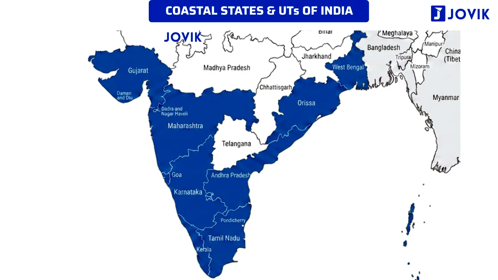
India’s peninsula is shaped like a broad triangle pointing southward. The Arabian Sea bounds it to the west, the Bay of Bengal to the east, and the Indian Ocean is at the tip of the peninsula. Due to the triangular form, India is blessed with two distinct coasts: a western coast and an eastern coast. Both coasts have their own characteristics and their own geographical features. Some states in India lie on the eastern coast, and others on the western coast.
India has the longest coastline in the Indian Ocean. The total length of the coastline is approximately 7,516 km.
There are a total of nine states and four Union Territories that are on the two sides of the Indian peninsula:
States on the Western Coast — Arabian Sea
- Gujarat
- Maharashtra
- Goa
- Karnataka
- Kerala
States on the Eastern Coast — Bay of Bengal
- Tamil Nadu
- Andhra Pradesh
- Odisha
- West Bengal
List of the four coastal Union Territories:
UT on the Western Coast — Arabian Sea
1. Dadra and Nagar Haveli and Daman and Diu
2. Lakshadweep
UT on the Eastern Coast — Bay of Bengal
1. Puducherry, and
2. The Andaman and Nicobar Islands
Coastline length ranking
Among all the coastal states, Gujarat has the longest coastline due to its irregular, heavily indented shoreline. Andhra Pradesh and Tamil Nadu are ranked second and third.
Apart from the coastline, India’s peninsula is bordered by several important enclosed or semi-enclosed water bodies, such as gulfs, straits, and channels.
Longest to Shortest ranking of border lengths (States):
|
# |
State |
Length |
Type |
|---|---|---|---|
|
1 |
Gujarat |
2,340.62 |
Longest among states |
|
2 |
Tamil Nadu |
1,068.69 |
2nd longest among states |
|
3 |
Andhra Pradesh |
1,053.07 |
|
|
4 |
Maharashtra |
877.97 |
|
|
5 |
West Bengal |
721.02 |
|
|
6 |
Kerala |
600.15 |
|
|
7 |
Odisha |
574.71 |
|
|
8 |
Karnataka |
343.30 |
|
|
9 |
Goa |
193.95 |
Shortest among States |
Longest to Shortest ranking of border lengths (States & UTs):
|
# |
State |
Length |
Type |
|---|---|---|---|
|
1 |
Andaman & Nicobar Islands |
3,083.50 |
Longest among states & UTs |
|
2 |
Gujarat |
2,340.62 |
2nd longest among states |
|
3 |
Tamil Nadu |
1,068.69 |
|
|
4 |
Andhra Pradesh |
1,053.07 |
|
|
5 |
Maharashtra |
877.97 |
|
|
6 |
West Bengal |
721.02 |
|
|
7 |
Kerala |
600.15 |
|
|
8 |
Odisha |
574.71 |
|
|
9 |
Karnataka |
343.30 |
Shortest among States |
|
10 |
Goa |
193.95 |
|
|
11 |
Lakshadweep Islands |
144.80 |
|
|
12 |
Daman & Diu |
54.38 |
|
|
13 |
Puducherry |
42.65 |
There is no need to remember the coastal length of the states. It is only given for reference and clarity. Only remember the length order.
Gulfs around India
Three gulfs border the coast of India. Each one is formed by a different geographic configuration and has its own importance.
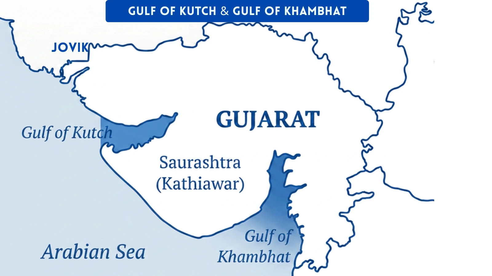
Gulf of Kutch
It is located on the western edge of Gujarat, near the Kutch district. The surrounding area is marshy and arid.
Gulf of Khambhat (Cambay)
A narrow arm of the Arabian Sea on the south-eastern coast of Gujarat. It is at the mouths of the Narmada and Tapti rivers. Both rivers drain into the Gulf of Khambhat. The funnel shape of the gulf creates high tidal ranges.
Gulf of Mannar
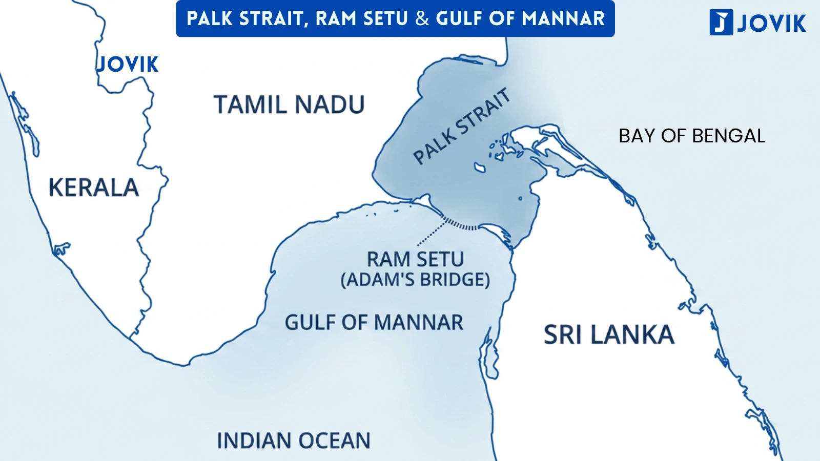
It lies between southern Tamil Nadu and the north-western coast of Sri Lanka. It forms the southern part of the narrow sea separating India and Sri Lanka. The Palk Strait connects the Gulf of Mannar to the Bay of Bengal to the north. Ram Setu (Adam’s Bridge) is a chain of limestone shoals that forms the boundary between them.
Palk Strait
A narrow strip of water between south-eastern India (Tamil Nadu) and north-western Sri Lanka. It connects the Bay of Bengal in the north to the Gulf of Mannar in the south. Ram Setu (Adam’s Bridge), a natural chain of limestone shoals, separates the Palk Strait from the Gulf of Mannar. This is the principal waterway that separates India from Sri Lanka.
Palk Strait vs Gulf of Mannar:
These two are adjacent but distinct. The Palk Strait is to the north, and it connects the Bay of Bengal to the Gulf of Mannar. The Gulf of Mannar lies to the south and opens into the Indian Ocean. Ram Setu marks the boundary between them.
Maritime neighbours of India
India’s maritime boundaries are shared with seven countries:
|
# |
State |
|---|---|
|
1. |
Pakistan |
|
2. |
Maldives |
|
3. |
Sri Lanka |
|
4. |
Bangladesh |
|
5. |
Myanmar |
|
6. |
Thailand |
|
7. |
Indonesia |
Territorial Limit of India
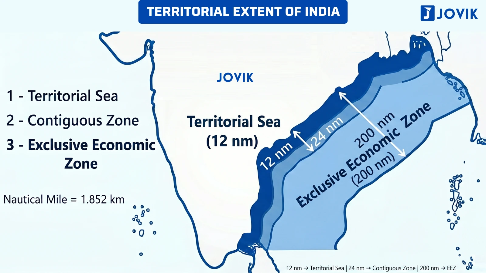
Beyond the visible coastline, India’s sovereign territory extends further into the sea, as defined by international maritime law under UNCLOS III.
India’s territorial sea extends up to 12 nautical miles from the coastline (Check Image). Within this zone, India has complete sovereign rights, the same as over its land territory.
STATUTE MILE
~1.6 km
= 63,360 inches
Used on Land
NAUTICAL MILE
~1.852 km
= 6,080 feet = 72,960 inches
Used at sea
Territorial sea = 12 nautical miles from the coastline.
India’s southernmost maritime boundary extends to 6° 45′ N latitude in the Bay of Bengal.
Memory Trick
G-R-M-C-J-W-T-M
Gujarat-Rajasthan-Madhya Pradesh-Chhattisgarh-Jharkhand-W. Bengal-Tripura-Mizoram
G R M C J W T M — “Great Rulers Must Cross Just West To Meet” (any personal phrase using these letters works; the sequence matters most).
Previous Year Questions
Q1. Indian Standard Time refers to the local time of which one of the following places in India? [NDA 2008-I]
- Allahabad
- Bhopal
- Delhi
- Lucknow
Answer: (A) Allahabad
Explanation: The ISM (82½° E) passes through Mirzapur. Since Mirzapur is not among the given options. So, the closest city to Mirzapur is (a) Allahabad.
Q2. The IST meridian 82.5° E passes through which set of states? [NDA 2015-II]
- Uttarakhand, UP, Chhattisgarh, AP
- UP, Jharkhand, Chhattisgarh, Odisha
- Uttarakhand, UP, MP, Chhattisgarh
- UP, Odisha, AP, Chhattisgarh
Answer: (A) Allahabad
Explanation: The ISM passes through exactly 5 states: UP, MP, Chhattisgarh, Odisha, and Andhra Pradesh.
Q3. What is the correct chronological order of sunrise for: [NDA 2018-II]
- Itanagar,
- Imphal,
- Agartala,
- Aizawl?
- 3–2–1–4
- 2–1–4–3
- 1–4–3–2
- 4–3–2–1
Answer: (A) Allahabad
Explanation: The farther east the city is, the earlier the sunrise will be. Among the four cities given, Itanagar (Arunachal Pradesh, ~94° E) is the easternmost, so it will see sunrise first. Aizawl (~92.7° E) will be the next, by Agartala (~91.3° E), and Imphal (~93.9° E) will be further east.
Q4. Sunrise in eastern Arunachal Pradesh would be about how many hours before sunrise in western Gujarat? [NDA 2017-II]
- One hour
- Two hours
- Three hours
- Four hours
Answer: (A) Allahabad
Explanation: The easternmost point of India in Arunachal Pradesh is at 97° E, and the westernmost point of India in Gujarat is at around 68° E. The longitudinal difference is roughly 29°. At 4 minutes per degree, it becomes 29 × 4 = 116 minutes ≈ , 2 hours.
Q5. The Indian Standard Time (IST) is based on: [NDA 2012-I]
- 90° E Meridian
- 82.5° E Meridian
- 75° E Meridian
- 0° Meridian
Answer: (B) 82.5° E Meridian
Explanation: As discussed earlier, Indian Standard Time is calculated from the 82.5°E meridian. We can write it in different ways, like 82.5° E or 82½° E.
Q6. Which of the following statements is/are correct? [NDA 2012-II]
- The local time of Itanagar (AP) is about two hours ahead than Dwarka (Gujarat).
- The local time at Chennai (TN) and Lucknow (UP) is almost the same.
- The local time in Mumbai is one hour ahead of Kolkata.
- 1 and 2 only
- 2 only
- 1 and 3 only
- 1, 2 and 3
Answer: (B) 82.5° E Meridian
Statement 1 is Correct—Itanagar (~94° E) and Dwarka (~69° E) are over 25° apart. Therefore, at 4 minutes per degree, it will take them more than 100 minutes (≈ almost 2 hours) to approximate the distance.
Statement 2 is Correct—Chennai (~80° E) and Lucknow (~81° E) are both located near the same longitude, thus having almost identical solar times in each location.
Statement 3 is Incorrect—While Mumbai (~73° E) is located to the west of Kolkata (~88° E), Delhi’s ~8 hours ahead of Mumbai places it before (i.e. earlier) Kolkata. The statement incorrectly reversed the east-west distance between two points.
Thus, only statements 1 and 2 are correct.
Remember: East will always be ahead in time. If a statement says a Western city is ahead of an eastern one, that will be wrong.
Q7. The Indian Standard Time is ahead of Greenwich Mean Time by: [NDA 2013-II]
- 3 hrs 30 min
- 4 hrs 30 min
- 5 hrs 30 min
- 6 hrs 30 min
Answer: (C) 5 hrs 30 min
82.5° × 4 min per degree = 330 minutes = 5 hours 30 minutes. IST is ahead of GMT by 5:30.
Among the given options, several other half-hour intervals have been included to create confusion.
Common Mistakes
INDIAN STANDARD MERIDIAN
TROPIC OF CANCER
Including Assam or Manipur — Both are Northeast states, but they lie outside the Tropic of Cancer Line. In north-eastern states, only Mizoram is on the line. Counting in Nagaland is another commonly committed mistake.
Confusing UP and Bihar as Tropic of Cancer states — They are large states, but the Tropic of Cancer does not pass through them. NDA 2011-I included them as incorrect options.
Forgetting the Bangladesh gap — The Tropic of Cancer line is not continuous within India. It exists in West Bengal, passes through Bangladesh, and re-enters India in Tripura.
Interchanging longest/shortest stretch — Madhya Pradesh has the longest stretch, Rajasthan has the shortest. The order is reversed to confuse the students.
Counting 3 coastal states — Some students count Andhra Pradesh or Odisha, which are not on the Tropic of Cancer. Only
Gujarat and West Bengal are included in the list. The correct count is 2 coastal, 6 landlocked.
LAND NEIGHBOURS OF INDIA & BOARDERING STATES
Assuming China or Pakistan share maximum border with India. Actually, Bangladesh is the longest border to share with India. The two times that this was tested were during the CDS 2008-I and CDS 2012-I (Bangladesh had the longest border).
Including Himachal Pradesh and Haryana along with Pakistan is incorrect. Himachal Pradesh and Haryana do not have a common border with Pakistan. The borders are J&K, Punjab, Rajasthan and Gujarat
Assuming Manipur shares a border with Bangladesh is incorrect. Manipur shares a border with Myanmar, not Bangladesh. The only 5 Indian states hared a border with Bangladesh are: West Bengal, Assam, Meghalaya, Tripura, and Mizoram.
INDIA’S COASTAL GEOGRAPHY
Assuming that Tamil Nadu or Andhra Pradesh has the longest coastline, Gujarat holds the record by a wide margin. Tamil Nadu is the only correct answer when Gujarat is not in the options.
Confusing with Palk Strait and Gulf of Mannar — the Palk Strait is to the north, connects the Bay of Bengal to the Gulf of Mannar, and is the main waterway that separates India from Sri Lanka. The Gulf of Mannar is to the south of the Palk Strait.
Confusing with statute mile and nautical mile in the feet conversion — 5,280 feet is a statute (land) mile, not a nautical mile. The nautical mile is 6,080 feet.
Placing the Gulf of Mannar on the Kerala or Karnataka coast: It is entirely on the south Tamil Nadu coast, adjacent to Sri Lanka. Kerala and Karnataka are on the opposite (west) coast.
Quick Revision
INDIAN STANDARD MERIDIAN
TROPIC OF CANCER
LAND NEIGHBOURS OF INDIA & BOARDERING STATES
INDIA’S COASTAL GEOGRAPHY